

©Peter Yates
South Coast Fjords Study Area
Feasibility assessment for a proposed national marine conservation area in southwestern Newfoundland
The Government of Canada, the Province of Newfoundland and Labrador, Miawpukek First Nation, Qalipu First Nation, and the Town of Burgeo recently signed a Memorandum of Understanding to work together to assess the feasibility of creating a national marine conservation area in the South Coast Fjords area on the southwest coast of the island of Newfoundland, and to assess the possibility of redesignating Sandbanks Provincial Park as a national park in southwestern Newfoundland.
The study area for the proposed national marine conservation area (NMCA) is approximately 9,112 square kilometres and is representative of the Laurentian Channel marine region, and the Sandbanks study area is 2.26 km2. This ecologically rich marine environment area is a productive marine ecosystem and biodiversity hotspot. It is amongst the most productive marine environments in Atlantic Canada and is home to the largest tides in Newfoundland. The spectacular rugged coast creates many sheltered inlets and habitats for a variety of marine species. It includes coastal and marine ecosystems that consist of forests of spruce-fir, rocky barrens, sand dunes, flat sandy beaches, large granite cliffs and deep fjords carved by glaciers. These waters are a key migration route for over 20 species of whales, and they are an important habitat for many endangered species including Atlantic cod, redfish and leatherback sea turtles. The marine region is also home to dolphins and porpoises, turtles, sharks, fishes, invertebrates, and seabirds.
Sandbanks Provincial Park, located near the Town of Burgeo, protects a fragile sand dunes ecosystem. The area contains extensive beaches and marshes that are home to the endangered piping plover and other migratory shorebirds, along with moose, black bear, mink, snowshoe hare, red fox, and the Newfoundland marten. The area is an ecotourism destination that provides a variety of recreational activities, including hiking, camping, scuba diving and nearby historical sites.
The Sandbanks and South Coast Fjords study areas include many archaeological sites of importance, depicting such cultures as Maritime Archaic, Dorset, Pre-Inuit, recent Indigenous and European. The strengthened protection of these special places would support the conservation of biodiversity and the fight against climate change, and would support the culture, traditions, and well-being of coastal and Indigenous communities who have long been stewards of these lands and waters. The proposed NMCA in the South Coast Fjords and the proposed redesignation of Sandbanks Provincial Park in this culturally and ecologically rich area will contribute to Canada’s and Newfoundland and Labrador’s growing network of protected and conserved areas. These protected areas help safeguard Canada’s biodiversity and provide opportunities for Canadians to experience the outdoors, learn about our environment, and significantly contribute to the protection and preservation of Canada’s most vulnerable ecosystems.
Current project stage
The establishment of a new NMCA generally follows a five-step process. The establishment process for each NMCA is as unique as its features and considerations. As such there is no specific timeframe for moving through the process.
This project is currently assessing the feasibility of an NMCA.
-
Completed1 Identify representative marine areas
-
Completed2 Select a candidate NMCA
-
Current step3 Assess feasibility of an NMCA
-
4 Negotiate establishment agreement(s)
-
5 Designate and protect NMCA in legislation
Map 1: National marine conservation area feasibility assessment study area

-
Long description
The map contains a legend in the top left corner and a smaller map of Atlantic Canada in the bottom left. A 0 to 60 kilometre scale is indicated in the bottom right corner, with a north arrow above it and the year 2023 below it. The bottom of the map shows logos of Parks Canada, Newfoundland and Labrador, Miawpukek First Nation, Qalipu First Nation, and the Town of Burgeo.
The map identifies the study area for the proposed national marine conservation area and national park in the South Coast Fjords of Newfoundland. The study area is approximately 9,112 square kilometres and is indicated in blue. It spans a stretch of the southwest coast of the island of Newfoundland between the eastern side of LaPoile Bay to the eastern side of McCallum, and extends offshore approximately 70 km to the south. The study area for the proposed national park, indicated in green, is adjacent to the Town of Burgeo, and is 2.26 square kilometres.
The communities of Kippens, Stephenville, Stephenville Crossing and St. George’s are identified in the northeast portion of the map. Channel-Port aux Basques, LaPoile, Burgeo, Grey River, Francois and McCallum are labelled along the shoreline of the Atlantic Ocean in the southeastern portion of the map. The island of Ramea is adjacent to the mainland between the communities of Burgeo and Grey River. Harbour Breton is identified in the east. Grand Bank and Fortune are labelled further east, as well as Saint-Pierre, France to the south.
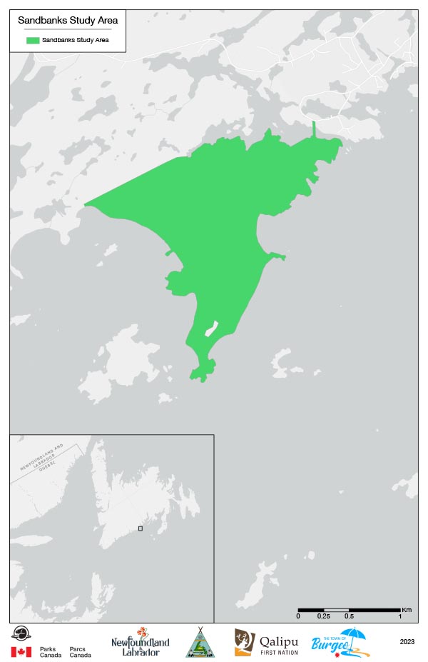
Map 2: Map of study area — Sandbanks study area, Newfoundland
-
Long description
The map contains a legend in the top left corner and a smaller map of Atlantic Canada in the bottom left. A 0 to 1 kilometre scale is indicated in the bottom right corner with the year 2023 below it. The bottom of the map shows logos of Parks Canada, Newfoundland and Labrador, Miawpukek First Nation, Qalipu First Nation, and the Town of Burgeo.
The map identifies Sandbanks Provincial Park in the South Coast Fjords of Newfoundland. The study area for the proposed redesignation as a national park—Sandbanks Provincial Park—is indicated in green and is 2.26 square kilometres. The study area is adjacent to the Town of Burgeo.
More Information
Contact us
Related links
- Government of Canada, Province of Newfoundland and Labrador, Miawpukek First Nation, Qalipu First Nation, and the Town of Burgeo will work together to assess the feasibility of creating a new national marine conservation area
- Newfoundland and Labrador
- Miawpukek First Nation
- Qalipu First Nation
- Town of Burgeo
- Sandbanks Provincial Park – ParksNL
- Date modified :